


The State of Open Data Programs: Commercial Satellite Imagery, 2026
Posted by Melissa Rosa, Bill Greer • Nov. 17, 2026
Executive summary
Commercial satellite imagery finer than 1 m is essential for humanitarian mapping, yet what providers call open ranges from searchable archives with clear reuse rights to a handful of samples licensed only for internal evaluation. This assessment reviews ten commercial optical and SAR providers across six dimensions: accessibility, searchability, licensing, currency and continuity, program support, and relevance. Four findings stand out:
01
Six providers lead, but none meets every humanitarian need. Vantor, Planet, Wyvern, Capella Space, ICEYE, and Umbra run substantial programs with clear reuse terms. Satellogic, Airbus, and Synspective offer partial access, and BlackSky offers no public imagery.
02
Open imagery covers the emergency, not what comes after. Programs either release imagery during major disasters (Vantor, Planet) or publish curated collections that showcase a sensor (Capella, ICEYE, Umbra, Wyvern). Neither reliably supports recovery, new baseline mapping, or preparedness.
03
Licensing is the biggest barrier. Non-commercial and evaluation-only terms rule out entire use cases, and only Vantor and Planet have explicitly permitted contributors to trace their imagery into OpenStreetMap.
04
Every element of a strong program already exists somewhere. No-login downloads, searchable catalogs, open licenses, regular releases, dedicated support, and published crisis protocols are each in practice at one or more providers. A shared standard is within reach.
HOT and Common Space invite providers to build on what they already do: publish clear terms, connect imagery to searchable catalogs, keep collections current, and extend releases beyond the acute phase of a disaster.
Commercial satellite imagery is critical to humanitarian response, climate resilience, public health, and other public good work, but access and usability vary widely1. During a crisis, responders need reliable, high-resolution imagery, ideally finer than 1 m, that they can quickly find and use to map damage, access routes, and areas where aid is needed. The same imagery supports recovery, new baseline mapping post-disaster, and preparedness for the next event, as well as responses to slow-onset crises such as drought and disasters that receive little global attention.
For imagery to serve humanitarian action, it must be open, but "open" can mean many things: a searchable, well-supported archive with clear reuse rights, a handful of older sample images, or imagery licensed only for internal evaluation. Open imagery offered by commercial satellite providers generally takes two forms: curated collections that demonstrate what a sensor can do, or imagery released during major disasters. Both types of open imagery are valuable, but neither fully meets humanitarian mapping needs.
Why this matters
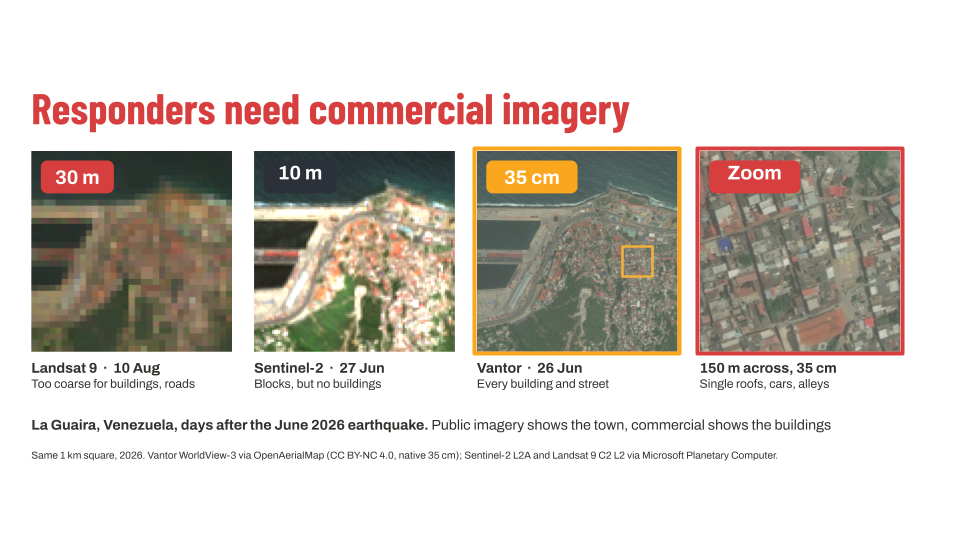
The same 1 km square of La Guaira, Venezuela, after the June 2026 earthquake. Public imagery shows the town; only commercial imagery shows the buildings responders need to map.
Source: Vantor WorldView-3 via OpenAerialMap (CC BY-NC 4.0); Sentinel-2 and Landsat 9 via Microsoft Planetary Computer.
In a natural disaster or crisis, responders need information from the ground to make urgent decisions, but hazardous conditions often make it hard to gather quickly, and in many situations it is unsafe to fly drones. Satellite imagery fills that gap. The Humanitarian OpenStreetMap Team (HOT), a global nonprofit that supports communities and humanitarian organizations with open mapping and geospatial data, sees that demand year-round, not only during emergencies. Disaster risk reduction, recovery, public health resilience, and environmental monitoring also rely on a current view from above.
Public investment in Earth observation is diverging with repeated proposed cuts in the U.S.2 and record investment in Europe3. Either way, public missions such as Sentinel-2 and Landsat, at 10 m and 30 m respectively, are too coarse to map individual buildings, so humanitarian organizations depend on commercial imagery. That makes the terms of access as important as the imagery itself.
In a disaster, access cannot depend on an organization’s ability to pay, and a license determines what it can do with the imagery once it has it. Open data programs offer imagery at no cost and can create value on both sides: they extend a provider’s reach to humanitarians, researchers, developers, and decision-makers who may not yet be users, letting them test real workflows and show where imagery makes a difference, which builds demand and trust before an organization can invest at scale.
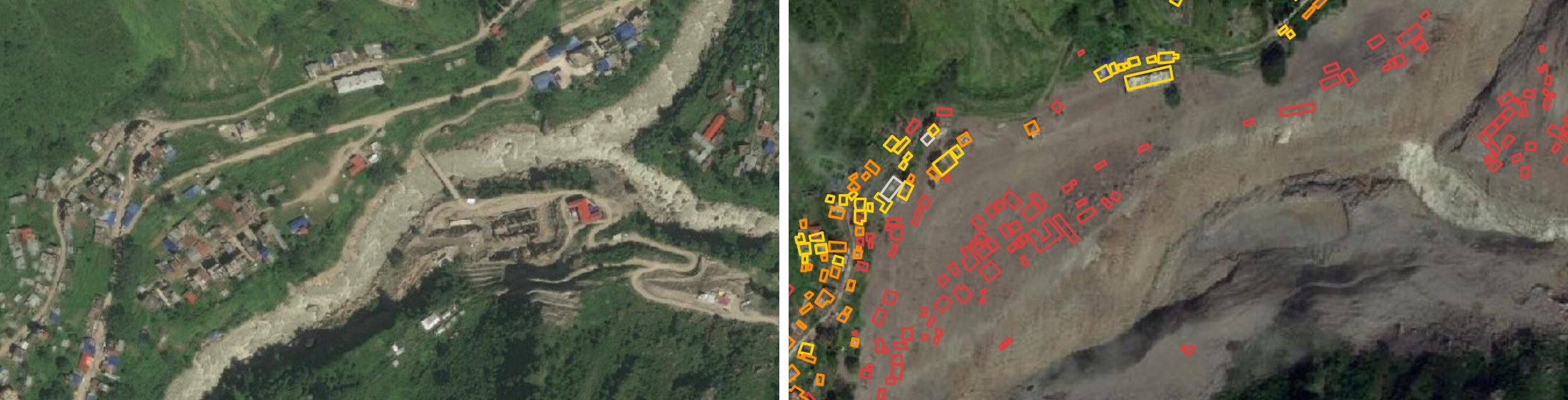
Syaphrubesi, Nepal, before (September 2023) and after (12 September 2026) the August floods in the Lhende Khola Valley. Buildings are colored by fAIr damage class: red for destroyed, orange for major damage and yellow for minor damage.
Source: Vantor imagery via OpenAerialMap (CC BY-NC 4.0). Read more in Mapping the Nepal floods.
Strong programs offer searchable catalogs, clear documentation, a point of contact, and enough current, high-quality imagery. Yet many programs release only sample data. Some collections are substantial, but curated samples are not an open archive because they may still contain no imagery for the right place or time a user needs to map.
This 2026 assessment draws clearer lines between the types of open imagery available, provider by provider. It shows that no single provider currently meets every humanitarian need, which makes open imagery standards that draw on each provider’s strengths essential. The goal is to help providers and humanitarian organizations move in the same direction with more imagery, fewer restrictions, and clearer terms.
Methodology
We assessed ten commercial optical and synthetic aperture radar (SAR) imagery providers across six dimensions using public information only. For providers with multiple programs, we assessed the broadest public offering. Arrangements granted privately to a single organization and contributions to the International Charter: Space and Major Disasters and NASA's Commercial Satellite Data Acquisition (CSDA) program4 are noted but not considered because that imagery does not reach the public. The six dimensions are:
- Accessibility: Imagery is available through an easily accessible website, with little or no registration, and can be downloaded directly.
- Searchability: Imagery is discoverable through a SpatioTemporal Asset Catalog (STAC) catalog or equivalent with sufficient metadata so non-technical users can search by place, time, or use case without knowing product names.
- Licensing: Imagery is released under a Creative Commons or comparable license that clearly defines reuse rights. Licensing carries the greatest weight because restrictive terms can rule out entire use cases regardless of how easy the data is to access5.
- Currency and continuity: Imagery is recent and the program remains active, with a regular update cadence rather than a one-time release.
- Program support: The program has a named contact or team, technical documentation such as tutorials and FAQs, and a clear process for requesting imagery, including during a disaster.
- Relevance: Imagery has useful spatial and temporal resolution, includes before-and-after imagery, and covers places that matter to users.
Provider categories
- Leading: Offers a substantial publicly accessible imagery program with clear reuse terms. Providers may still have fixable gaps in coverage, documents, or support, but the program is active and there is visible investment behind it.
- Partial: Publishes some imagery, but availability, relevance, currency, or license terms limit broader use. Examples include archives that are no longer updated and sample libraries restricted to evaluation.
- Restricted: Offers neither a public open data program nor sample imagery.
| Provider | Sensor | What's openly available |
|---|---|---|
| Leading | ||
| Vantor | Optical | Disaster event releases |
| Planet | Optical | Disaster event releases; curated open collection |
| Wyvern | Optical (hyperspectral) | Curated open collection |
| Capella Space | SAR | Curated open collection |
| ICEYE | SAR | Curated open collection |
| Umbra | SAR | Curated open collection; some disaster events |
| Partial | ||
| Satellogic | Optical | Curated open collection |
| Airbus | Optical | Evaluation-only samples |
| Synspective | SAR | Evaluation-only samples |
| Restricted | ||
| BlackSky | Optical | None |
Provider profiles
Leading: disaster response programs
Vantor (optical)
Vantor provides very-high-resolution optical satellite imagery (down to 30 cm) with global coverage and a long-standing archive. Its open data program focuses on disaster events and provides data in a public, no-login bucket on the Amazon Web Services (AWS) Open Data Registry, with a public STAC catalog that can be browsed through Radiant Earth's STAC browser and Development Seed's STAC Map.
In 2026, Vantor released before-and-after imagery for ten events. The data is licensed under CC BY-NC 4.0, which requires attribution. Vantor has granted OSM and HOT an exemption to trace over imagery, which CC BY-NC 4.0 usually does not allow. Vantor contributes to the International Charter and CSDA, and is the only provider in this assessment that publishes an activation protocol. Older open data remains available through the legacy Maxar STAC Index catalog and Geospatial Platform. Vantor also runs philanthropic programs, including the Purpose Partner Program, which provides imagery to selected nonprofit organizations to support a wide range of environmental and social causes. These program participants require an application or established relationship and operate separately from their open data program.
What would make it stronger: Extend releases beyond acute natural disaster events for longer-term recovery and new baseline mapping, and create dedicated program support to field requests and guide new users.
Planet (optical)
Planet operates the largest commercial fleet of Earth observation satellites, including PlanetScope (multispectral, about 3.7 m), SkySat (about 50 cm), Tanager (hyperspectral, about 30 m) and their newest satellite, Pelican (30 cm). Its disaster data is free to download without an account, with a STAC catalog for each event, under CC BY-NC 4.0, which requires attribution. Planet released imagery for multiple events in 2026, with before-and-after imagery from three satellite types. Planet has also published a waiver allowing its disaster imagery to be traced, used for vector feature extraction, or used to create derivative vector datasets for OpenStreetMap.
Planet also publishes a curated collection of open data from other missions and programs, including Tanager and Planet University, under a mix of Creative Commons licenses, including CC BY-SA 4.0 and CC BY 4.0, both of which require attribution. Planet maintains an active Planet Community forum, participates in the International Charter and CSDA, and offers application-based access through their Education and Research program (with a free tier for university students and faculty), and data grant programs, such as Project Centinela and Planetary Security.
What would make it stronger: Extend releases beyond active disasters to recovery, new baseline mapping, and preparedness.
Leading: curated open collections
Capella Space (SAR)
Capella operates a commercial SAR constellation providing all-weather, day-and-night imagery at resolutions as fine as 25 cm. Imagery is available in a public bucket on the AWS Open Data Registry under CC BY 4.0, including commercial use, with attribution required. It has a STAC index, an interactive map, and a STAC browser that can be searched by use case. No registration is required. Researchers and educators can apply for additional access through Capella’s Data Cooperative and Data Grant program, and there is a dedicated open data mailbox. Capella also participates in the CSDA.
What would make it stronger: The collection is largely curated examples, and the most recent scene in its open data gallery is from July 2025. It includes disaster response imagery, but none of 2026’s major disasters is covered in its open collection.
Umbra (SAR)
Umbra provides commercial SAR imagery as fine as 25 cm. Its open data program provides access through AWS Open Data Registry and STAC catalog with no sign-up required, and the data is licensed under CC-BY-4.0, which requires attribution. The archive includes dense time series over fixed sites and imagery from several recent disasters. Umbra also publishes Product Guides and participates in the CSDA.
What would make it stronger: Coverage of major disasters is selective. Its STAC catalog has not been updated since August 2025, the browse site requires a password, and the public bucket can be difficult to search manually. The registry’s license link also redirects to Umbra's website terms of use rather than to the CC BY 4.0 license.
ICEYE (SAR)
ICEYE operates a large constellation of small SAR satellites focused on frequent revisit and rapid response, with resolution finer than 25 cm in some imaging modes. ICEYE's Open Data Initiative launched this year and provides access through an interactive map browser, STAC browser, and AWS Registry, with around 490 scenes from 2024 to 2026 under CC BY 4.0, which requires attribution, and no registration requirement. ICEYE also participates in the International Charter and CSDA.
What would make it stronger: The catalog is organized mainly by imaging mode rather than place or event, so imagery for a particular area is harder to find. No scenes are labeled as disaster events, and an older evaluation license and a separate non-commercial thumbnail archive are still online and may confuse new users.
Wyvern (optical, hyperspectral)
Wyvern offers hyperspectral imagery with sensors that capture 23-31 spectral bands at approximately 5m spatial resolution. Wyvern started its open data program less than two years after its first satellite launched. No sign-up is required, and imagery can be explored through a map browser and STAC browser organized by application, spectral range, and year. Its knowledge center, spectral index library, and product guide give new users substantial onboarding support, making hyperspectral data far more approachable. Wyvern participates in the CSDA.
What would make it stronger: The collection is small, with about 130 scenes, only seven of them from 2026, which is consistent with a program that is less than two years old. Its CC BY 4.0 license, which requires attribution, is published only as a PDF linked from catalog metadata, while the metadata itself still carries a "proprietary" label and an "All Rights Reserved" notice.
Partial
Satellogic (optical)
Satellogic operates a multispectral optical fleet designed for high-cadence Earth observation: The NewSat constellation images at 50 cm super-resolved with the Mark V and Mark VI satellites, and the Merlin constellation, whose first satellite launched in October 2026, is designed to remap the planet daily at 1 meter super-resolved. The company serves government and commercial customers with imagery and AI/ML-ready products. Its EarthView dataset is one of the largest open releases in this assessment, with millions of image chips under CC BY 4.0, freely downloadable from AWS, its STAC Browser, and HuggingFace.
The data was captured in the second half of 2022 and has not been updated since. It consists of small 384-by-384-pixel tiles designed for machine learning rather than full-scene mapping. Satellogic contributes to the International Charter, and its imagery is also available under license to approved researchers through CSDA.
What would make it stronger: Current, full-scene imagery. The open datasets are organized mainly by date and are best suited for AI model development. Data searches by geography or use case would make the large volume of imagery easier to find and evaluate.
Airbus (optical)
Airbus provides optical and radar satellite imagery, including 30 cm resolution imagery from its Pléiades Neo constellation. Users can explore a sample imagery library by submitting a request and agreeing to a Technical Evaluation Licence. The licence allows internal technical evaluation for six months but prohibits third-party sharing. Users must provide copyright attribution and delete the data at the end of the licence term, with written confirmation.
While Airbus does not operate an open data program, it provides free imagery through its scientific research and disaster response programs and participates in the International Charter and CSDA. Airbus also offers free trials of its Living Library archive and Global Basemap streaming services. These trials provide access to a limited amount of imagery through the OneAtlas Data web interface or API for evaluation. Users can also access the optical archive as guests to search available imagery without downloading data.
What would make it stronger: An open program and license. Airbus imagery is available for evaluation through free trials and research and disaster response programs, but not under an open license that allows sharing and reuse. While its archive can be searched through the OneAtlas API with a trial account, publishing the sample library in a STAC catalog would make the samples more accessible.
Synspective (SAR)
Synspective operates a constellation of small SAR satellites (StriX) that deliver sub-meter imagery, and provides analytics for applications including disaster response, infrastructure monitoring, and environmental monitoring. Its public gallery includes about a dozen data samples that can be requested through a form under an evaluation license, which limits use to internal evaluation for 90 days, prohibits machine-learning training, and caps published images at 1,024 pixels. The gallery is searchable by country, date, tag, and imaging mode, but there is no machine-readable catalog.
What would make it stronger: An open program and license, and a STAC or other machine-readable catalog that supports broader evaluation and application.
Restricted
BlackSky (optical)
BlackSky operates a high-revisit optical satellite constellation and combines imagery as fine as 35 cm from its Gen-3 satellites with analytics and alerting through its Spectra AI platform, serving government and commercial customers in areas including defense, finance, critical infrastructure, and event monitoring. BlackSky offers no open data access or public sample imagery. It contributes to the International Charter, and US government-affiliated users can access its imagery through CSDA, but there is no route for the wider public.
The gap: any public open data or sample imagery offering.
What a strong program actually looks like
No provider meets every mark yet, but every mark is already met by someone. Together, the best practice in this assessment looks like this:
- Anyone can download imagery without an account, as Capella, Umbra, and ICEYE do.
- The catalog is searchable by place, event, or use case, as Capella’s is, or organized around the applications a sensor supports, as Wyvern’s is.
- The license is open, stated clearly in one place, and explicitly permits contribution to OpenStreetMap. Capella’s CC BY 4.0 license provides broad reuse rights. Vantor and Planet published exceptions specifically permitting OSM contributors to trace their imagery despite their non-commercial licenses.
- Releases are regular and recent. Vantor's and Planet's 2026 disaster releases demonstrate the value of current event-based imagery.
- There are people and processes behind the data: a dedicated contact and a way to request imagery, as at Capella; an active user community, as at Planet; and tutorials and user guidance, as at Wyvern.
- Crisis terms are set in advance, as Vantor does through its published activation protocol.
Even a strong program that did all of this would still leave an important gap. Current open programs are largely curated collections or imagery released during active disasters, not the imagery for recovery, baseline, and preparedness that humanitarian organizations and communities also need.
This is why Common Space is building a humanitarian satellite constellation to democratize access to high-resolution imagery and help fill that gap with open imagery for places and periods commercial programs may not cover. But no single constellation can do it all. Sensors differ in resolution, revisit rate, and capability, so humanitarian mapping requires an ecosystem of satellites in which commercial providers will remain essential.
Imagery providers can build on their existing work: publish the terms they already honor, connect open imagery to searchable STAC catalogs, keep collections current, and use consistent metadata so platforms such as OpenAerialMap (OAM) can bring providers’ imagery together in one place. Then extend releases beyond the acute phase of a disaster into recovery, and establish formal open data programs around these practices. This makes imagery easier to find and use for humanitarian, conservation, and other public good efforts. HOT and Common Space welcome the opportunity to help build these programs alongside providers.
Closing
Open data can save lives and build trust with new user communities, but programs require sustained investment and thoughtful licensing. This is the first edition of what we hope will become an annual assessment of provider investment and the value open data programs create for users and the companies behind the data.
To commercial providers: We welcome conversations about how open data can support your mission, user adoption, and long-term value. If you are considering an open data program or want to connect existing imagery with the humanitarian missions that need it, Common Space and HOT are here to help.
To humanitarian organizations, researchers and the open data community: Use this assessment to identify potential data partners, and always check licenses, attribution requirements, and current terms before using a dataset. For downstream imagery, contact OAM at info@openaerialmap.org.
The conversation continues at SatSummit 2026 in St. Louis on November 18–19, where we will share more about this step with Planet and discuss how open Earth observation data can become standard practice, how open data programs can create value for both providers and the public, and what comes next. Learn more about SatSummit →
References
- Open, and Out of Reach: Access Is Not Accessibility, Data Commons ↑
- Deja vu: Trump proposes cutting NASA science funding by 47% again, Space.com ↑
- ESA 2026 budget rises 7.6%, Advanced Television ↑
- Nine of the ten providers take part in CSDA. ↑
- We note whether imagery can be traced into OpenStreetMap. The OpenStreetMap Foundation asks for explicit permission even for CC BY 4.0 imagery, so the license alone rarely settles it. What matters is whether the provider publishes that permission. ↑
Share